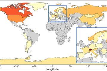
Performance of climate projections for Yukon and adjacent Northwest Territories.
La conception des infrastructures sur le pergélisol doit tenir compte des impacts du changement climatique sur la stabilité du sol. Alors que des lignes directrices comme la CSA PLUS 4011:19 fournissent un cadre, le choix de scénarios climatiques appropriés reste un défi.
L'étude par Astrid Schetselaar, Trevor Anderson et Chris Burn révèle que le réchauffement observé au Yukon et dans les Territoires du Nord-Ouest (1991 à 2020) correspond aux projections climatiques extrêmes réalisées en 2003 pour le projet gazier Mackenzie.
Points clés à retenir pour les développeurs :
- Envisagez d’adopter des scénarios de changement climatique plus agressifs lors de la conception des fondations du pergélisol, car ces projections sont plus précises.
- Le pergélisol proche de la surface dans les parties méridionales de la région pourrait devenir insoutenable. Des études approfondies du site pour détecter les sols stables au dégel sont cruciales.
- La hausse des températures hivernales signifie que l'efficacité opérationnelle des thermosiphons, utilisés pour refroidir les fondations, pourrait être entravée. Sur les sites où la préservation du sol gelé est essentielle à l’intégrité des infrastructures, le nombre de thermosiphons requis peut devoir augmenter.
Schetselaar, A.B., Andersen, T.S., and Burn, C.R. 2023. Performance of climate projections for Yukon and adjacent Northwest Territories, 1991-2020. Arctic, 76(3). doi: 10.14430/arctic77263