A prototype field-to-publication data system for a multi-variable permafrost observation network.

A prototype field-to-publication data system for a multi-variable permafrost observation network.
Blog post by Nick Brown, NSERC PermafrostNet Data Scientist

Analysis and prediction of permafrost change are hampered by lack of observational data. In collaboration with Stephan Gruber, Peter Pulsifer, and Amos Hayes, we developed a permafrost data management system to support permafrost observation networks that involve many different kinds of permafrost data.

We identify five broad challenges for permafrost data management and publication: (1) existing data management strategies do not scale well, (2) data users have different skills and needs, (3) permafrost data are varied, (4) resources for permafrost data management are limited, and (5) existing permafrost data sources are difficult to integrate. Our prototype system supports a permafrost data workflow from observation to the distribution of interoperable data. The system simplifies data publication and management, although we identify and discuss several hurdles in adapting the CF conventions and ERDDAP for permafrost data. Our learning can inform organizations who collect, manage, or distribute permafrost data or those who manage large observation networks.

In summary:

  • Five broad challenges limit permafrost data management and publication.
  • We frame these challenges as requirements, and identify similarities with the FAIR principles.
  • We developed a prototype a permafrost data system to support field-to-publication workflows.
  • In this project, we use an “adopt and adapt” approach for standards and software.
  • Our data system supports more FAIR permafrost data.

Nicholas Brown, Stephan Gruber, Peter Pulsifer, Amos Hayes, A prototype field-to-publication data system for a multi-variable permafrost observation network, Environmental Modelling & Software, Volume 175, 2024, 106006, ISSN 1364-8152, doi:10.1016/j.envsoft.2024.106006

This research was enabled in part by support provided by Compute Ontario and the Digital Research Alliance of Canada.

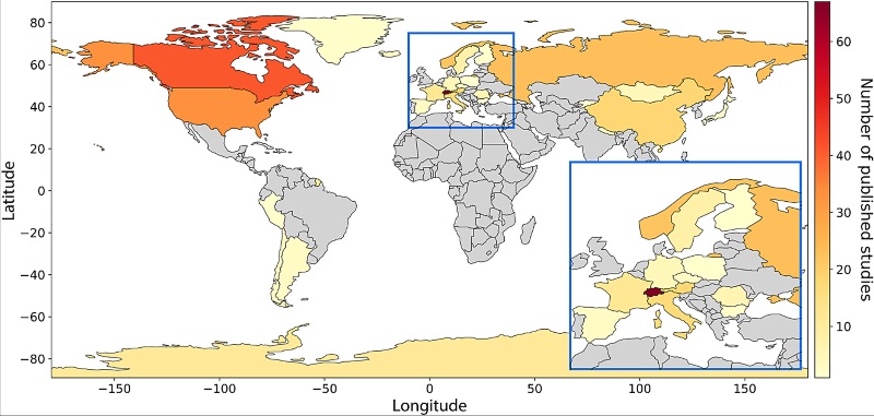
Global map summarizing locations of field sites where electrical resistivity tomography (ERT) has been used to study permafrost (2000–22) based on the literature search.

Best practices for using electrical resistivity tomography to investigate permafrost.

Best practices for using electrical resistivity tomography to investigate permafrost

A recent study by Teddi Herring suggests ways to improve how Electrical Resistivity Tomography (ERT) is used for permafrost and highlights recent advances in this approach. ERT is a technique that is incredibly useful for studying permafrost, enabling us to see how deep the permafrost layer is and identify areas with ice content.

There has been a 10-fold increase in publications of studies using ERT to analysis permafrost in the last 20 years, and though challenges remain, and there’s no single “best way” to do it yet, the study makes recommendations for conducting ERT surveys to maximize the utility of existing and future data.

Herring T,  Lewkowicz AG,  Hauck C, et al.  Best practices for using electrical resistivity tomography to investigate permafrostPermafrost and Periglac Process.  2023; 34(4): 494-512. doi:10.1002/ppp.2207

Global map summarizing locations of field sites where electrical resistivity tomography (ERT) has been used to study permafrost (2000–22) based on the literature search.