Investigating the controls of ice-wedge initiation and growth using XFEM

A study of how climate, soil type and water saturation affect ice-wedge cracks

A new study by Gabriel Karam et al asks, how do climate and soil control the ice-wedge formation process?

Answering these questions can further our understanding of wedge-ice volume and distribution.
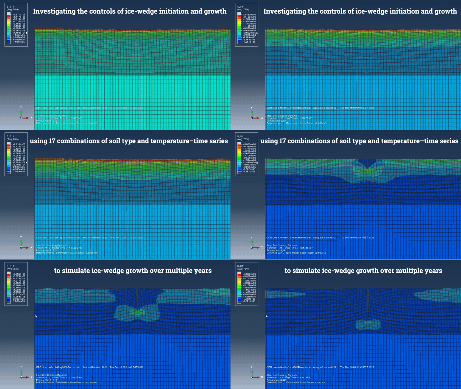
Ice wedge cracking simulation gif

Ice-wedges are periglacial landforms that develop as a result of thermal contraction-cracking in continuous permafrost regions, which appear as polygonal networks on the ground surface. Given their complex thermo- mechanical loading history, very few related numerical models have so far been developed. This study developed a new climate-driven model to show the fractures in soil that develop from thermal contraction in winter. The range of model results indicate how climate, soil type and water saturation of the soil affect the spacing, depth, and width of ice-wedge cracks. Estimating ice-wedge depth can help us make informed volume calculations which are otherwise difficult to measure in the field.

Karam, G., Pouragha, M. and Gruber, S. (2024). Investigating the controls of ice-wedge initiation and growth using XFEM, Computers and Geotechnics, Volume 173, DOI: 10.1016/j.compgeo.2024.106549

A typical simulation result showing multiple cracks.

A prototype field-to-publication data system for a multi-variable permafrost observation network.

A prototype field-to-publication data system for a multi-variable permafrost observation network.
Blog post by Nick Brown, NSERC PermafrostNet Data Scientist

Analysis and prediction of permafrost change are hampered by lack of observational data. In collaboration with Stephan Gruber, Peter Pulsifer, and Amos Hayes, we developed a permafrost data management system to support permafrost observation networks that involve many different kinds of permafrost data.

We identify five broad challenges for permafrost data management and publication: (1) existing data management strategies do not scale well, (2) data users have different skills and needs, (3) permafrost data are varied, (4) resources for permafrost data management are limited, and (5) existing permafrost data sources are difficult to integrate. Our prototype system supports a permafrost data workflow from observation to the distribution of interoperable data. The system simplifies data publication and management, although we identify and discuss several hurdles in adapting the CF conventions and ERDDAP for permafrost data. Our learning can inform organizations who collect, manage, or distribute permafrost data or those who manage large observation networks.

In summary:

  • Five broad challenges limit permafrost data management and publication.
  • We frame these challenges as requirements, and identify similarities with the FAIR principles.
  • We developed a prototype a permafrost data system to support field-to-publication workflows.
  • In this project, we use an “adopt and adapt” approach for standards and software.
  • Our data system supports more FAIR permafrost data.

Nicholas Brown, Stephan Gruber, Peter Pulsifer, Amos Hayes, A prototype field-to-publication data system for a multi-variable permafrost observation network, Environmental Modelling & Software, Volume 175, 2024, 106006, ISSN 1364-8152, doi:10.1016/j.envsoft.2024.106006

This research was enabled in part by support provided by Compute Ontario et du Digital Research Alliance of Canada.

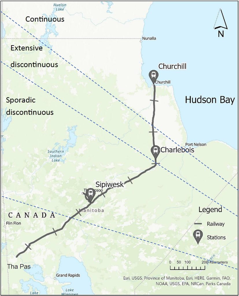
The study area showing the Hudson Bay Railway extending from Churchill to The Pas, Manitoba.

A study of thermal modeling parameters and their impact on modelled permafrost responses to climate warming

A study of thermal modeling parameters and their impact on modelled permafrost responses to climate warming

Une étude par Khatereh Roghangar et Jocelyn Hayley a évalué les effets des paramètres de modélisation thermique sur la réponse du pergélisol au réchauffement climatique. Ils ont analysé comment les variations de profondeur, de teneur en eau et de type de sol affectent les prévisions des profondeurs futures des couches actives et du tassement selon divers scénarios climatiques en utilisant les caractéristiques du sol le long du corridor ferroviaire de la baie d'Hudson.

Les résultats indiquent que, pour les sols à grains fins, la profondeur du modèle est un paramètre plus significatif que pour les sols à grains grossiers. La teneur en eau de tous les types de sol est un facteur essentiel pour déterminer le moment auquel le pergélisol dégèle et la profondeur à laquelle se situe la couche active, car une teneur en eau plus élevée entraîne des changements plus importants dans la couche active et un tassement plus important dans la plupart des cas. Ces découvertes ont des implications importantes pour la gestion des infrastructures et de l’utilisation des terres dans la région arctique.

Roghangar, K. and Hayley, J.L. (2024). A study of thermal modeling parameters and their impact on modelled permafrost responses to climate warmingCold Regions Science and Technology, 221, 104155, DOI: 10.1016/j.coldregions.2024.104155.

The study area showing the Hudson Bay Railway extending from Churchill to The Pas, Manitoba.
Zone d'étude montrant le chemin de fer de la Baie d'Hudson s'étendant de Churchill à The Pas, au Manitoba.

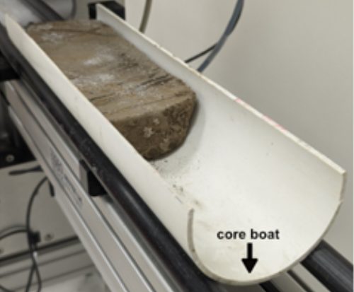
Core in the core boat on the MSCL track.

Non-destructive multi-sensor core logging allows for rapid imaging and estimation of frozen bulk density and volumetric ice content in permafrost cores.

Non-destructive multi-sensor core logging allows for rapid imaging and estimation of frozen bulk density and volumetric ice content in permafrost cores

Des recherches passionnantes dans le laboratoire scientifique Permafrost ArChivesPACS Labde l'Université de l'Alberta a démontré une nouvelle application de la diagraphie multicapteurs pour l'analyse des carottes de pergélisol.

Les mesures des propriétés physiques principales sont généralement destructrices et prennent beaucoup de temps.

L’enregistrement multicapteurs non destructif (non-destructive multi-sensor core logging ou MSCL) peut analyser efficacement des échantillons de pergélisol et fournir des informations à haute résolution sans ces problèmes. Cette nouvelle technique permet une imagerie rapide, une mesure de la densité apparente et une estimation de la teneur en glace des carottes de pergélisol. L'équipe a pu visualiser des cryostructures et estimer la densité apparente gelée, la susceptibilité magnétique et la teneur volumétrique en glace.

La nouvelle technique est décrite dans l'article publié dans la revue The Cryosphere by Duane Froese’s lab: Pumple, J., Monteath, A., Harvey, J., Roustaei, M., Alvarez, A., Buchanan, C., and Froese, D.: Non-destructive multi-sensor core logging allows for rapid imaging and estimation of frozen bulk density and volumetric ice content in permafrost cores, The Cryosphere, 18, 489–503, https://doi.org/10.5194/tc-18-489-2024, 2024.

Core in the core boat on the MSCL track.
Cœur dans le support de cœur (« core boat ») sur le rail de MSCL.

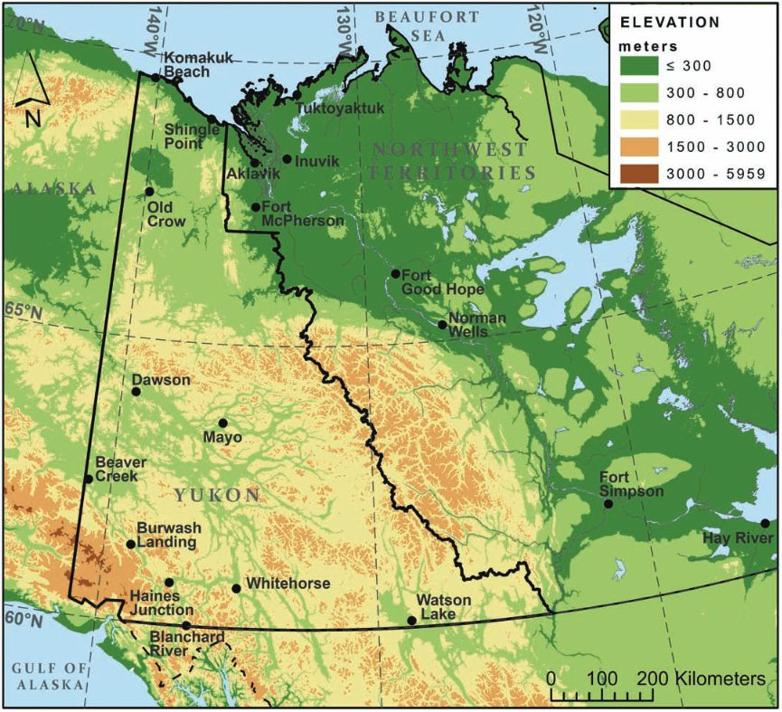
Yukon Territory and western Northwest Territories, including Mackenzie Mountains and adjacent Mackenzie River Valley, with locations of all weather stations.

Performance of climate projections for Yukon and adjacent Northwest Territories.

Performance of climate projections for Yukon and adjacent Northwest Territories.

La conception des infrastructures sur le pergélisol doit tenir compte des impacts du changement climatique sur la stabilité du sol. Alors que des lignes directrices comme la CSA PLUS 4011:19 fournissent un cadre, le choix de scénarios climatiques appropriés reste un défi.

L'étude par Astrid Schetselaar, Trevor Anderson et Chris Burn révèle que le réchauffement observé au Yukon et dans les Territoires du Nord-Ouest (1991 à 2020) correspond aux projections climatiques extrêmes réalisées en 2003 pour le projet gazier Mackenzie.

Points clés à retenir pour les développeurs :

  • Envisagez d’adopter des scénarios de changement climatique plus agressifs lors de la conception des fondations du pergélisol, car ces projections sont plus précises.
  • Le pergélisol proche de la surface dans les parties méridionales de la région pourrait devenir insoutenable. Des études approfondies du site pour détecter les sols stables au dégel sont cruciales.
  • La hausse des températures hivernales signifie que l'efficacité opérationnelle des thermosiphons, utilisés pour refroidir les fondations, pourrait être entravée. Sur les sites où la préservation du sol gelé est essentielle à l’intégrité des infrastructures, le nombre de thermosiphons requis peut devoir augmenter.

Schetselaar, A.B., Andersen, T.S., and Burn, C.R. 2023. Performance of climate projections for Yukon and adjacent Northwest Territories, 1991-2020. Arctic, 76(3). doi: 10.14430/arctic77263

Yukon Territory and western Northwest Territories, including Mackenzie Mountains and adjacent Mackenzie River Valley, with locations of all weather stations.
Territoire du Yukon et ouest des Territoires du Nord-Ouest, y compris les monts Mackenzie et la vallée adjacente du fleuve Mackenzie, avec l'emplacement de toutes les stations météorologiques.

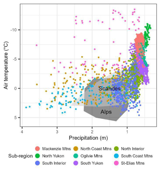
Comparison of mountain areas with permafrost in western Canada (coloured) and European areas (grey) for mean annual air temperature and total annual precipitation at a resolution of 30 km x 30 km.

Transfert des connaissances sur la cryosphère entre les montagnes au niveau mondial : Une étude de cas des montagnes de l’Ouest canadien, des Alpes européennes et des Scandes

Transfert des connaissances sur la cryosphère entre les montagnes au niveau mondial : Une étude de cas des montagnes de l’Ouest canadien, des Alpes européennes et des Scandes

La plupart des recherches sur le pergélisol de montagne se sont concentrées sur la petite zone des Alpes européennes. Cela nous amène à la question suivante : pouvez-vous transférer les connaissances sur la cryosphère des Scandes et des Alpes au Canada?

Emilie Stewart-Jonesa développé une méthode permettant de comparer les climats régionaux à une échelle grossière afin de mettre en évidence les similarités et les différences. Son articleTransfert des connaissances sur la cryosphère entre les montagnes au niveau mondial : Une étude de cas des montagnes de l’Ouest canadien, des Alpes européennes et des Scandespublié dans le Journal of Alpine Research en novembre peut désormais répondre à la question de savoir si nous pouvons transférer nos connaissances sur le pergélisol d'une région à une autre.

Comparison of mountain areas with permafrost in western Canada (coloured) and European areas (grey) for mean annual air temperature and total annual precipitation at a resolution of 30 km x 30 km.
Comparaison des zones montagneuses avec pergélisol dans l'ouest du Canada (en couleur) et dans les régions européennes (en gris) pour la température annuelle moyenne de l'air et les précipitations annuelles totales à une résolution de 30 km x 30 km.

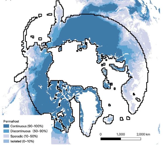
Coverage of the ArcticDEM in the Arctic with permafrost extent.

Identifying active retrogressive thaw slumps from ArcticDEM

 Identifying active retrogressive thaw slumps from ArcticDEM

L’ampleur du dégel du pergélisol dans la région panArctique reste inconnue, mais la télédétection, l’apprentissage profond et le « crowdsourcing » aident à cartographier la dégradation du pergélisol dans le paysage.

L'étude récente de Huang et al fournit des données et sert à dresser un inventaire mondial et à mieux comprendre le dégel du pergélisol dans la région panarctique grâce à la télédétection à très haute résolution. Cette approche pourrait conduire à un inventaire mondial des effondrements régressifs liés au dégel.

Lingcao Huang, Michael J. Willis, Guiye Li, Trevor C. Lantz, Kevin Schaefer, Elizabeth Wig, Guofeng Cao, Kristy F. Tiampo, Identifying active retrogressive thaw slumps from ArcticDEM, ISPRS Journal of Photogrammetry and Remote Sensing, Volume 205, 2023, Pages 301-316, ISSN 0924-2716.

Coverage of the ArcticDEM in the Arctic with permafrost extent.
Couverture de l'ArcticDEM dans l'Arctique avec étendue du pergélisol.

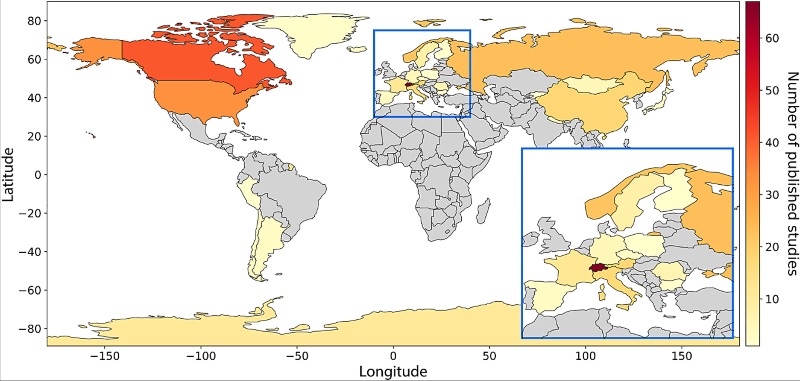
Global map summarizing locations of field sites where electrical resistivity tomography (ERT) has been used to study permafrost (2000–22) based on the literature search.

Best practices for using electrical resistivity tomography to investigate permafrost.

Best practices for using electrical resistivity tomography to investigate permafrost

Une étude récente de Teddi Herring suggère des moyens d'améliorer la façon dont la tomographie par résistivité électrique (Electrical Resistivity Tomography ou ERT) est utilisée pour le pergélisol et met en évidence les progrès récents dans cette approche. L'ERT est une technique extrêmement utile pour étudier le pergélisol, car elle nous permet de connaître la profondeur de la couche de pergélisol et d'identifier les zones contenant de la glace.

Le nombre de publications d'études utilisant l'ERT pour analyser le pergélisol a été multiplié par 10 au cours des 20 dernières années, et bien que des défis demeurent et qu'il n'existe pas encore de « meilleure façon » unique de le faire, l'étude formule des recommandations pour mener des études ERT afin de maximiser l’utilité des données existantes et futures.

Herring T,  Lewkowicz AG,  Hauck C, et al.  Best practices for using electrical resistivity tomography to investigate permafrostPermafrost and Periglac Process.  2023; 34(4): 494-512. doi:10.1002/ppp.2207

Global map summarizing locations of field sites where electrical resistivity tomography (ERT) has been used to study permafrost (2000–22) based on the literature search.
Carte mondiale résumant les emplacements des sites de terrain où la tomographie par résistivité électrique (ERT) a été utilisée pour étudier le pergélisol (2000 à 2022) sur la base de la recherche documentaire.

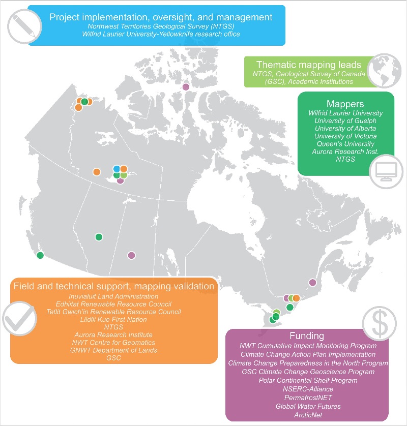
Project organization, roles and institutional involvement by location.

The Northwest Territories Thermokarst Mapping Collective: a northern-driven mapping collaborative toward understanding the effects of permafrost thaw

The Northwest Territories Thermokarst Mapping Collective: a northern-driven mapping collaborative toward understanding the effects of permafrost thaw.

Un article du Thermokarst Mapping Collective (TMC), une collaboration de recherche visant à inventorier systématiquement les indicateurs de sensibilité au dégel du pergélisol par cartographie et évaluations aériennes dans les Territoires du Nord-Ouest (NT), au Canada, a documenté le premier inventaire complet des terrains thermokarst et d’indicateurs sensibles au dégel pour une région de 2 millions de kilomètres2 carrés du nord-ouest du Canada.

Kokelj, S.V. et alThe Northwest Territories Thermokarst Mapping Collective: a northern-driven mapping collaborative toward understanding the effects of permafrost thawArctic Science. E First. DOI: 10.1139/as-2023-0009.

Project organization, roles and institutional involvement by location.
Organisation du projet, rôles et implication institutionnelle par localisation.

New publication: Ground subsidence and heave over permafrost.

Ground subsidence and heave over permafrost: hourly time series reveal interannual, seasonal and shorter-term movement caused by freezing, thawing and water movement.

Heave and subsidence of the ground surface can offer insight into processes of heat and mass transfer in freezing and thawing soils. Additionally, subsidence is an important metric for monitoring and understanding the transformation of permafrost landscapes under climate change. Corresponding ground observations, however, are sparse and episodic. A simple tilt-arm apparatus with logging inclinometer has been developed to measure heave and subsidence of the ground surface with hourly resolution and millimeter accuracy. This contribution reports data from the first two winters and the first full summer, measured at three sites with contrasting organic and frost-susceptible soils in warm permafrost. The patterns of surface movement differ significantly between sites and from a prediction based on the Stefan equation and observed ground temperature. The data are rich in features of heave and subsidence that are several days to several weeks long and that may help elucidate processes in the ground. For example, late-winter heave followed by thawing and subsidence, as reported in earlier literature and hypothesized to be caused by infiltration and refreezing of water into permeable frozen ground, has been detected. An early-winter peak in heave, followed by brief subsidence, is discernible in a previous publication but so far has not been interpreted. An effect of precipitation on changes in surface elevation can be inferred with confidence. These results highlight the potential of ground-based observation of subsidence and heave as an enabler of progress in process understanding, modeling and interpretation of remotely sensed data.

Gruber, S.: Ground subsidence and heave over permafrost: hourly time series reveal interannual, seasonal and shorter-term movement caused by freezing, thawing and water movement. The Cryosphere, 14, 1437–1447, https://doi.org/10.5194/tc-14-1437-2020, 2020.